-
-
About Upazila
Introduce to Upazila
History & Tradition
Geography & Economics
-
Upazila Parishad
উপজেলা পরিষদ
উপজেলা পরিষদের মাসিক সমন্বয় সভা সংক্রান্ত
স্থায়ী কমিটির সভার কার্যবিবরণী
-
আইন-শৃংখলা কমিটি
-
যোগাযোগ ও ভৌত অবকাঠামো উন্নয়ন কমিটি
-
কৃষি ও সেচ কমিটি
-
মাধ্যমিক ও মাদ্রাসা শিক্ষা কমিটি
-
প্রাথমিক ও গণশিক্ষা কমিটি
-
স্বাস্থ্য ও পরিবার কল্যাণ কমিটি
-
যুব ও ক্রীড়া উন্নয়ন কমিটি
-
মহিলা ও শিশু উন্নয়ন কমিটি
-
সমাজ কল্যাণ কমিটি
-
মুক্তিযোদ্ধা কমিটি
-
মৎস্য ও প্রাণি সম্পদ কমিটি
-
পল্লী উন্নয়ন ও সমবায় কমিটি
-
সাংস্কৃতিক বিষয়ক কমিটি
-
পরিবেশ ও বন উন্নয়ন কমিটি
-
অর্থ, বাজেট, পরিকল্পনা ও স্থানীয় সম্পদ আহরণ কমিটি
-
জনস্বাস্থ্য, স্যানিটেশন ও বিশুদ্ধ পানি সরবরাহ কমিটি
-
বাজার মূল্য পর্যবেক্ষণ, মনিটরিং ও নিয়ন্ত্রণ কমিটি
প্রকল্প সম্পর্কিত তথ্য
বার্ষিক উন্নয়ন পরিকল্পনা
পঞ্চবার্ষিক পরিকল্পনা
বাজেট
-
আইন-শৃংখলা কমিটি
-
Upazila administration
Upazila Nirbahi Officer
About Organogram
Schedule & Meeting
Services and others
-
Government office
Health and environmental issues
Land and revenue matters
Engineering and information and communication technology
Human resource development issues
Others
Matters of law and order
Education matters
Agriculture, fisheries, animal and food matters
-
Different Institutions
Educational Institutions
- E-services
- Gallery
মেনু নির্বাচন করুন
-
-
About Upazila
Introduce to Upazila
History & Tradition
Geography & Economics
-
Upazila Parishad
উপজেলা পরিষদ
উপজেলা পরিষদের মাসিক সমন্বয় সভা সংক্রান্ত
স্থায়ী কমিটির সভার কার্যবিবরণী
- আইন-শৃংখলা কমিটি
- যোগাযোগ ও ভৌত অবকাঠামো উন্নয়ন কমিটি
- কৃষি ও সেচ কমিটি
- মাধ্যমিক ও মাদ্রাসা শিক্ষা কমিটি
- প্রাথমিক ও গণশিক্ষা কমিটি
- স্বাস্থ্য ও পরিবার কল্যাণ কমিটি
- যুব ও ক্রীড়া উন্নয়ন কমিটি
- মহিলা ও শিশু উন্নয়ন কমিটি
- সমাজ কল্যাণ কমিটি
- মুক্তিযোদ্ধা কমিটি
- মৎস্য ও প্রাণি সম্পদ কমিটি
- পল্লী উন্নয়ন ও সমবায় কমিটি
- সাংস্কৃতিক বিষয়ক কমিটি
- পরিবেশ ও বন উন্নয়ন কমিটি
- অর্থ, বাজেট, পরিকল্পনা ও স্থানীয় সম্পদ আহরণ কমিটি
- জনস্বাস্থ্য, স্যানিটেশন ও বিশুদ্ধ পানি সরবরাহ কমিটি
- বাজার মূল্য পর্যবেক্ষণ, মনিটরিং ও নিয়ন্ত্রণ কমিটি
প্রকল্প সম্পর্কিত তথ্য
বার্ষিক উন্নয়ন পরিকল্পনা
পঞ্চবার্ষিক পরিকল্পনা
বাজেট
-
Upazila administration
Upazila Nirbahi Officer
About Organogram
Schedule & Meeting
Services and others
-
Government office
Health and environmental issues
Land and revenue matters
Engineering and information and communication technology
Human resource development issues
Others
Matters of law and order
Education matters
Agriculture, fisheries, animal and food matters
-
Different Institutions
Educational Institutions
- E-services
-
Gallery
Photo Gallery
Video Gallery
Main Comtent Skiped
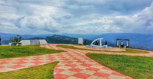
Thanchi on the map
Thanchi Thanchi upazila on the map covers an area of 1020.82 sq km. It is the largest upazila of Bandarban district. Location of Thanchi upazila. The distance from Bandarban district headquarters to this upazila is about 85 km. Lama Upazila, Alikadam Upazila and Rakhine State of Myanmar to the west; Rakhine State of Myanmar is located in the south and Chin Province of Myanmar is located in the west.

Site was last updated:
2025-02-25 00:45:37
Planning and Implementation: Cabinet Division, A2I, BCC, DoICT and BASIS


